
Written : Dr. Nabil Sameh
1. Introduction
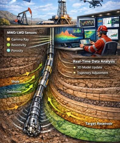
Geosteering is a critical discipline in modern directional and horizontal drilling operations. It represents the real-time process of adjusting the well trajectory based on subsurface geological data to ensure optimal placement within a target reservoir. As hydrocarbon reservoirs become more complex and economically sensitive, the precision of well placement has become a decisive factor in field performance.
Unlike conventional drilling, where the trajectory is largely predefined, geosteering introduces dynamic decision-making into the drilling process. It integrates geological interpretation, petrophysical evaluation, and drilling mechanics to maintain the wellbore within productive zones. The discipline has evolved significantly with advancements in logging-while-drilling (LWD), measurement-while-drilling (MWD), and real-time data transmission technologies.
This article provides a theoretical exploration of geosteering techniques, focusing on principles, methodologies, technologies, challenges, and strategic considerations.
2. Fundamentals of Geosteering
Geosteering is fundamentally the intersection between geology and directional drilling. Its objective is to maximize reservoir contact by continuously interpreting formation data while drilling and adjusting well trajectory accordingly.
At its core, geosteering relies on three primary components:
Geological model
Real-time formation evaluation
Directional control capability
The geological model provides an initial understanding of structural geometry, stratigraphy, and reservoir distribution. However, subsurface uncertainty is inevitable. Therefore, real-time data acquisition during drilling becomes essential to update interpretations and refine well placement.
Geosteering is particularly important in:
Thin reservoirs
Highly faulted formations
Structurally complex traps
Unconventional shale plays
Extended reach wells
The theoretical concept revolves around reducing subsurface uncertainty while drilling, transforming the well from a static trajectory into a dynamically guided path.
3. Types of Geosteering Techniques
Geosteering techniques can be broadly categorized into structural, stratigraphic, and property-based steering.
3.1 Structural Geosteering
Structural geosteering focuses on maintaining the well within a defined structural framework, such as staying above a contact or within a specific fault block. It relies heavily on dip interpretation from LWD tools and correlation with pre-drill seismic models.
The primary objective is to control vertical position relative to structural markers.
3.2 Stratigraphic Geosteering
Stratigraphic steering aims to follow specific lithological units. This approach is common in layered reservoirs where productivity depends on staying within a certain facies.
It requires detailed understanding of:
Lithology transitions
Formation tops and bottoms
Gamma ray trends
Resistivity contrasts
3.3 Property-Based Geosteering
Property-based geosteering uses petrophysical properties such as resistivity, density, or porosity trends to guide well placement. This method is particularly relevant in unconventional plays where the objective is to remain within the most productive rock quality interval.
Rather than strictly following structural markers, it focuses on maximizing reservoir quality.
4. Data Acquisition Technologies
Geosteering depends on continuous data acquisition during drilling. Modern techniques rely primarily on downhole measurement tools integrated into the bottom hole assembly.
4.1 Measurement While Drilling (MWD)
MWD provides directional data such as inclination, azimuth, and toolface orientation. It ensures the well trajectory follows planned directional targets.
4.2 Logging While Drilling (LWD)
LWD tools provide formation evaluation data in real time. These measurements may include:
Gamma ray
Resistivity
Density
Neutron porosity
Sonic response
Advanced deep-reading resistivity tools can detect formation boundaries several meters away from the wellbore. This capability significantly enhances predictive steering.
4.3 Real-Time Data Transmission
Mud pulse telemetry and other transmission systems allow surface teams to receive data during drilling. This enables immediate interpretation and decision-making.
The theoretical framework of geosteering assumes continuous feedback between subsurface measurements and trajectory adjustments.
5. Real-Time Interpretation Process
The geosteering workflow is iterative and adaptive. It involves:
Comparing real-time logs with the pre-drill model
Identifying deviations from predicted geology
Updating structural interpretation
Recommending directional adjustments
Geosteering engineers must interpret subtle log responses and correlate them with expected formation characteristics. The process requires both analytical skills and geological intuition.
Theoretical interpretation focuses on pattern recognition, trend analysis, and formation boundary detection. Small shifts in log signatures can indicate approaching formation tops or bottoms.
The ability to anticipate geological changes before drilling into them is one of the defining aspects of advanced geosteering.
6. Directional Control Mechanisms
Geosteering would not be possible without directional drilling technologies capable of rapid trajectory adjustment.
These include:
Rotary steerable systems
Mud motors with bent housings
Adjustable stabilizer systems
Rotary steerable systems allow continuous rotation while steering, improving wellbore quality and directional precision. They enable smoother corrections and better control in thin targets.
The theoretical principle involves aligning mechanical capability with geological interpretation. Without precise directional control, even accurate geological interpretation would not translate into effective well placement.
7. Geological Uncertainty and Model Updating
Subsurface models are inherently uncertain. Geosteering reduces this uncertainty by continuously updating interpretations based on new data.
The concept of model updating includes:
Revising structural depth predictions
Adjusting formation dip estimates
Refining fault interpretations
Updating reservoir thickness assumptions
Geosteering transforms drilling into an information-gathering process. Each drilled meter reduces uncertainty and improves understanding of reservoir geometry.
Adaptive modeling is central to theoretical geosteering philosophy.
8. Challenges in Geosteering
Despite technological advancements, geosteering remains complex and challenging.
8.1 Thin Reservoir Targets
Maintaining well placement within thin pay zones requires high precision and rapid interpretation.
8.2 Complex Structural Environments
Faulted or folded reservoirs introduce unpredictable changes in dip and formation position.
8.3 Data Limitations
Telemetry speed constraints may limit data resolution. Additionally, tool reliability and environmental effects can impact measurement quality.
8.4 Human Interpretation
Geosteering relies heavily on expert judgment. Different interpreters may reach varying conclusions based on the same data.
Theoretical best practice emphasizes multidisciplinary collaboration to mitigate these challenges.
9. Integration with Digital Technologies
Modern geosteering increasingly integrates digital platforms and predictive modeling.
Digital enhancements include:
Real-time 3D visualization
Automated log correlation
Predictive formation boundary detection
Machine learning-assisted interpretation
While still guided by human expertise, digital tools enhance speed, accuracy, and consistency of decision-making.
The theoretical evolution of geosteering is moving toward semi-autonomous optimization supported by advanced analytics.
10. Strategic Importance of Geosteering
Geosteering directly impacts:
Reservoir contact length
Well productivity
Recovery factor
Development cost efficiency
Precise well placement improves drainage efficiency and reduces non-productive intervals. In unconventional reservoirs, geosteering can significantly influence stimulation effectiveness and overall field performance.
The discipline is no longer optional in complex reservoirs; it is foundational to economic viability.
Conclusion
Geosteering represents one of the most transformative advancements in modern drilling operations. It bridges geology, petrophysics, and drilling engineering into a unified real-time decision-making process.
The theoretical foundation of geosteering lies in reducing subsurface uncertainty through continuous data interpretation and adaptive trajectory control. By integrating real-time formation evaluation with advanced directional technologies, wells are no longer drilled blindly but guided intelligently through complex geological environments.
As reservoirs become increasingly challenging and margins tighten, geosteering will continue evolving. Digital transformation, predictive analytics, and automation are expected to further enhance its precision and efficiency.
Ultimately, geosteering is not merely a technique—it is a philosophy of dynamic well placement driven by geological insight, technological capability, and multidisciplinary collaboration.
Written by Dr.Nabil Sameh
-Business Development Manager (BDM) at Nileco Company
-Certified International Petroleum Trainer
-Professor in multiple training consulting companies & academies, including Enviro Oil, ZAD Academy, and Deep Horizon , Etc.
-Lecturer at universities inside and outside Egypt